Let Jesus Calm Your Storm

As I write this, Tropical Cyclone Alfred is heading for Brisbane and is expected to wreak havoc though the Sunshine Coast and Gold Coast areas as well as into the North Coast of New South Wales.

Tropical cyclones, called hurricanes or typhoons in other parts of the world, are very intense low pressure systems that generate huge winds and heavy rainfall, sometimes over very big areas. They can cause destruction and flooding and people rightly get nervous when a cyclone approaches. Readers of a certain age will recall Cyclone Tracey which on Christmas Eve 1974 flattened most of Darwin and killed 66 people.

Cyclones are very important in regulating the earth’s temperature. They are like conveyor belts for energy taking heat energy from the tropics and transporting it to more temperate regions. That is great for the planet, but not so good when people get in the way.

We often speak of storms as descriptions for what is happening in our lives. Relationships can be stormy. Angry individuals act like cyclones, destroying everyone they encounter. Sometimes we might go through a “perfect storm” where everything seems to be coming against us and it all threatens to overwhelm us.

On one occasion some followers of Jesus were caught out on the sea at night time in a tiny boat when a huge storm blew up. The waves threatened to sink the boat. They were already terrified when a ghostly figure approached them, walking on the water. One of them, Peter, called out, “Lord if it’s really you command me to walk on the water.” With that, Peter stepped out of the boat and strode across the waves that had a short time before scared him. (See Matthew 14:22-33)

You might be going through a “perfect storm” right now. Cyclone Alfred is nothing compared to the personal devastation you are fearing or feeling. Hand over all your cares to the Lord and put your trust in Him. He still calms the storms and gives us the grace to stride across them confidently.

More Extreme Weather Events?

When the earth failed to burst into flames, or even to heat at the rates the computers predicted, the activists pointed to what they called extreme weather events such as tornadoes and cyclones. They were supposed to increase in number and intensity. 

The reality? Not so much. In fact the long term trend is actually the reverse of that, at least in Australia and the U.S.

From wattsupwiththat.com

2018 will be the first year with no violent tornadoes in the United States


From LMT Online

In the whirlwind that is 2018, there has been a notable lack of high-end twisters.

We’re now days away from this becoming the first year in the modern record with no violent tornadoes touching down in the United States. Violent tornadoes are the strongest on a 0 to 5 scale, or those ranked EF4 or EF5.

It was a quiet year for tornadoes overall, with below normal numbers most months. Unless you’re a storm chaser, this is not bad news. The low tornado count is undoubtedly a big part of the reason the 10 tornado deaths in 2018 is also vying to be a record low.

While we still have several days to go in 2018, and some severe weather is likely across the South to close it out, odds favor the country making it the rest of the way without a violent tornado.

If and when that happens, it will be the first time since the modern record began in 1950.

2005 came close to reaching this mark. That year, the first violent tornado didn’t occur until Nov. 15, much later than typical for the first of the year, which tends to come in early spring.

This year’s goose-egg may seem to fit a recent pattern.

In simple terms, there have been down-trends in violent tornado numbers both across the entire modern period, and when looking at just the period since Doppler radar was fully implemented across the country in the mid-1990s. A 15-year average as high as 13.7 in the mid-1970s will drop to 5.9 next year.

Expanding to include all “intense” tornadoes, or those F/EF3+, this year’s 12 is also poised to set a record for the least.

Right now, the mark there is held by 1987 when there were 15 F3+ tornadoes. As with violent tornadoes, this grouping is also exhibiting both a short and long-term decrease in annual numbers, likely for similar reasons.

The causes for 2018′s lack of violent tornadoes are many, but one key factor is high pressure tending to be more dominant than normal throughout peak season this past spring. This was particularly so during April and May, when tornado numbers were below to well below normal.

Although the country ended up seeing a number of memorable tornado events after the spring, including several this fall, in most years over half of the tornadoes occur from March through May. Making up those numbers is difficult at other times of the year when ingredients for them are less likely.

Despite the downtrend in annual numbers, studies continue to find that more tornadoes are happening on fewer days. In that light, it is certainly possible this drought won’t last much longer

BOM Caught Out Hyping Results Again

Cyclone Marcie was a terrible storm. It has been reported as “Cat-5” which is the top of the cyclone/ hurricane scale.

The devastation, though widespread has not been as severe as you might have been expected.

The BOM was forecasting that the cyclone would become Cat-5 and of course the media ran with that, but in the event, as far as we can measure these things it made landfall as a Cat-3.

So it the BOM doing to cyclones what it has been doing to temperature records? Are they being re-categorised to march the global warming mantra of “more extreme weather”?

Of course if we believe that Rockhampton and Yeppoon survived a Cat-5 and it was only really a Cat-3 will that lead to relaxed building standards and complacency that could be fatal when a real Cat-5 storm comes.

Sigh! I used to be a real fan of science untll it became just another propaganda vehicle.

From Jo Nova:

Category Five storms aren’t what they used to be

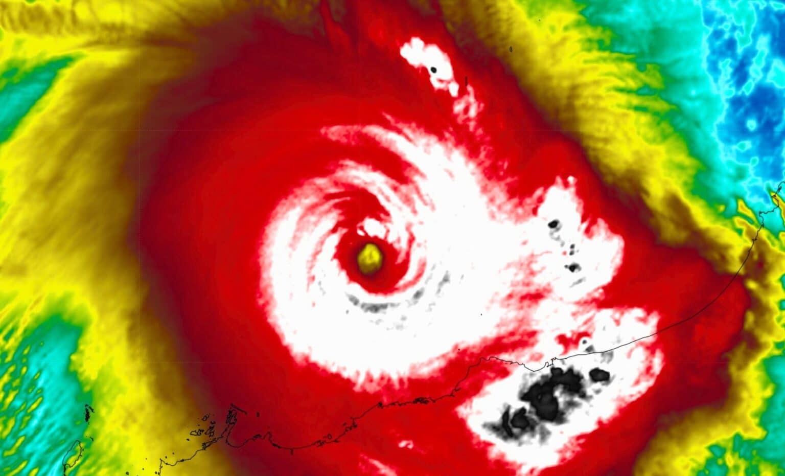
The facts on Cyclone Maria: the top sustained wind speed was 156 km and the strongest gust 208 km/hr. These were recorded on Middle Percy Island in the direct path before it hit land and apparently rapidly slowed.  The minimum pressure recorded after landfall was 975Hpa. BOM and the media reported a “Cat-5″ cyclone with winds of 295 km/hr. To qualify as a Cat 5, windspeeds need be over 280km/hr. The UN GDACS alerts page estimated the cyclone as a Cat 3.

The damage toll so far is no deaths (the most important thing), but 1,500 houses were damaged and 100 families left homeless. It was a compact storm, meaning windspeeds drop away quickly with every kilometer from the eye, so the maps and locations of the storm and the instruments matter. See the maps below — the eye did pass over some met-sites, but made landfall on an unpopulated beach with no wind instruments. It slowed quickly thereafter. The 295 km/hr wind speed was repeated on media all over the world, but how was it measured? Not with any anemometer apparently — it was modeled. If the BOM is describing a Cat 2 or 3 as a “Cat 5″, that’s a pretty serious allegation. Is the weather bureau “homogenising” wind speeds between stations?

What will happen when Australians living in cyclone areas have to prepare for real Cat 5s? How much respect will Australians have for the BOM (and the ABC) if they find out that supposedly dispassionate and impartial scientists have been hyping weather events to score political points? Will the BOM issue any clarifications and corrections?

What does a Cat 5 mean anymore?

The headlines are still calling Marcia a “Cat 5″ cyclone three days later. But today there are many questions about that, and very different debates have broken out on the old media and the new. On the mainstream media, Premier Annastacia Palaszczuk is already defending the BOM after the Marcia “surprise”. But she is talking about the sudden escalation of a Cat 1 or 2 up to a 5, and whether the BOM gave residents enough warning. On the Internet people are asking why it was called a Cat 5. As Jennifer Marohasy points out, the top speeds recorded showed the cyclone was a Category 3. “Middle Percy” was under the path, and out to sea.

There is a weather station on Middle Percy, and it recorded a top wind speed of 156 km/h, the strongest gust was 208 km/h, and the lowest central pressure was 972 hPa. This raw observational data is available at the Bureau’s website and indicates a category 3 cyclone.

As commenters unmentionable and Ken recorded here, none of the observed wind-speeds came remotely close to being Cat 5. By strange coincidence, two guest authors here, Ken Stewart and TonyfromOz, live north of Rockhampton and both “walked in the eye” last Friday. I’ve spoken to both this morning, and fortunately their houses and families are OK, though still without electricity.

The US Navy’s Joint Typhoon Warning Centre was tracking the cyclone and, like me, noted the surface observations from Middle Percy Island. The US Navy had been estimating wind speeds based on the Dvorak modelling method. This method is considered much less reliable than aircraft reconnaissance, with surface observations (from anemometers and barometers) historically the ultimate measure of a tropical cyclone’s wind speed and central pressure. For example, in the case of Cyclone Yasi, a barograph at Tully sugar mill recorded a minimum central pressure of just 929 hPa, and this is the value in the final report from the Australian Bureau of Meteorology confirming that Yasi was a category 5 system.

In the case of Marcia, the US Navy acknowledged that their Dvorak estimates were higher than the surface observations from Middle Percy Island. In particular their real time “warning”, no longer available on the internet, noted an “intensity of 110 knots” based on the anemometer on Middle Percy. This corresponds with the highest wind gust recorded on Middle Percy Island as Marcia passed over. The maximum sustained wind speed, however, never exceeded 156 km/h, and the central pressure was never less than 972 hPa. This makes Marcia a category 3 based on the Australian system, and only a category 2 based on the Saffir-Simpson Hurricane Wind Scale.

Yet the bureau continued to report the cyclone, not as it was, based on the surface observations, but as they had forecast it in a media release the previous day: “Tropical Cyclone Marcia to reach Category 5 system at landfall”.

Full story here